THE HISTORICAL SIGNIFICANCE
OF CHISKA TALOFA,
A TOWN OF YUCHI ORIGIN ON THE WEST BANK
OF THE CHATTAHOOCHEE RIVER: 1757-1818
by Robert Register
A TOWN OF YUCHI ORIGIN ON THE WEST BANK
OF THE CHATTAHOOCHEE RIVER: 1757-1818
by Robert Register
1757: Chisca Talofa is the only
town in the area of present-day southeast Alabama located on
the 1757 Bonar Map (DeVorsey 1971). Swanton (1922) equated this with Yuchi-speaking
Hogologee indicated on earlier maps.
1761: Swanton(1922) lists a 1761 census figure of 30 for this town's population.
1764: John Stuart, British Indian agent for the Southern District, held a conference at St. Marks on September 13, 1764 which included leaders of Chisca Talofa located on the Chattahoochee above the fork.
1768: Pittman describes a crossing place for the Pensacola-St. Augustine trail on the river at the village of Ichiscatalonfa located on the west bank of the river, forty miles above the fork. (The 31st parallel [Alabama-Florida line] crosses the river 26.2 miles above the fork of the Chattahoochee and the Flint.)
1778: The Purcell map of the Pensacola-St. Augustine trail includes the notation Chisca Old Fields just north of Ekanachatte or Red Ground. This site was located by Boyd (1958) south of Irwin's Mill Creek adjacent to present-day Neal's Landing.
1799: Stephen Minor, Spanish commissioner during Ellicott's survey of the Southern Boundary of the United States, http://cgi.ebay.com/JOURNAL-OF-ANDREW-ELLICOTT-1814-maps-LouisiannaTerr-NR_W0QQitemZ200150050690QQihZ010QQcategoryZ29223QQssPageNameZWDVWQQrdZ1QQcmdZViewItem
names the village at the end of the compass line on the west bank of the Chattahoochee
as Chiscotofa or Clisteofa. The conflict which led to the survey being abandoned began
in this camp at the surveyor's observatory. This conflict was the beginning of the
unrelenting hostility of the Seminoles to the U.S.
In his Journal, Andrew Ellicott fails to mention that this international boundary line
between the U.S. & Spain cut Chisca Talofa in two. This was the only village along the
381 mile survey of the 31st latitude between the Mississippi and the Chattahoochee cut
in two by the first Southern Boundary of the U.S.
Here's a description of Chisca Talofa in August of 1799:
"Now from one side to the other of the river along almost the entire extent
of the road to this camp may be found Indian plantations of which may
be seen good fields of corn, rice, peas, beans, potatoes, melons,
watermelons, cucumber, etc., and most of them have chickens, pigs,
and cattle in abundance. Some of them have very good herds [along] with
Negro slaves, indicating to me that they live in reasonable comfort.
The river abounds with various delicious fish. All these details convince
me that white settlements in these areas would prosper greatly. I am sure
that on the eastern bank of the Mississippi there are no better lands on
which to raise cattle."
English translation of a letter from Stephen Minor to
Spanish West Florida Governor Gayoso (Minor to
Gayoso, August 5, 1799, Archivo General de Indias,
Papeles de Cuba, Seville, Legajo 2355)
1799: Between July 25, 1799 and August 19, 1799, Ellicott made 44 observations of
seven stars to determine a mean latitude of 31 degrees 1' 9.4" for his observatory on the
west bank of the Chattahoochee. Ellicott laid off a line 7110.5 feet south and ended his
survey of the 31st parallel which established the present day boundaries shared by
Louisiana, Mississippi, Alabama and Florida.
1799: In October, William Augustus Bowles,http://en.wikipedia.org/wiki/William_Augustus_Bowles
self-proclaimed Director General of the Nation
of Muskogee, returned to Wekiva, six miles north of the Florida line. He called a general
council of the Lower Creeks and Seminoles to distribute gunpowder and rum which
had been salvaged from the wreck of the British sloop Fox.
Here on the east bank of the
Chattahoochee just northeast of Chisca Talofa, Bowles reestablished his influence after
escaping from seven years of imprisonment by the Spanish.
1804: At Chisca Talofa on
May 25, 1804, James Innerarity and William Hambly represented
John Forbes & Co. in negotiations for a land grant. The company sought this payment
from the Indians to counterbalance Bowles' destruction of the company's Wakulla store
and the tribe's accumulated debt. This deed of cession was signed by 24 chiefs and
ultimately deeded to John Forbes & Co. 1,200,000 acres east of the Apalachicola.
Under the terms of this pact, the company agreed to immediately open a store at
Prospect Bluff on the Apalachicola near present-day Sumatra, Florida. This store
led to the later establishment of Nichol's British Fort, the Negro Fort and U.S. Fort
Gadsden near Prospect Bluff.
Click here to see a large map of the Forbes Purchase http://www.libs.uga.edu/darchive/hargrett/maps/1821f6.jpg
1810: At Chisca Talofa on April 10, 1810, Edmund Doyle, principal agent of John Forbes & Co.
on the Apalachicola, and William Hambly, interpreter & representative of the
company, secured the cession of three more tracts of land that joined the original 1804
grant. This included St. Vincent Island. These Indians also ceded to John Forbes
personally an island in the Apalachicola River. This 9,811 acre island is known
today as Forbes Island.
1814: On August 9, 1814, the chief of Chisca Talofa was one of the Creek chiefs who signed
the Treaty of Ft. Jackson which ceded over 20 million acres of present-day Alabama
Georgia to the United States.
1816: At Chisca Talofa on April 17, 1816, William Hambly attempted to unite the Upper
Towns friendly to the Americans and the Lower Towns friendly to the British in an
attack upon the Negro Fort on Prospect Bluff. This meeting was a disaster and Hambly
was forced to flee.
The Negro Fort was destroyed by the U.S. Navy on July 27, 1816.
270 of the fort's occupants were killed instantly by a single explosion
of the fort's powder magazine. Captured British arms and supplies were
valued at not less that $200,000
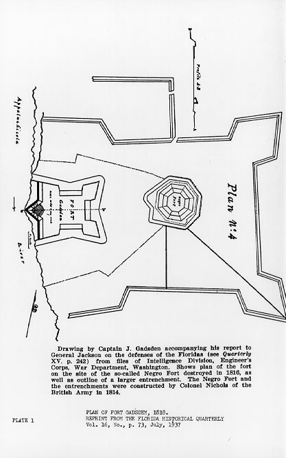
A MAP OF THE NEGRO FORT BASED
UPON ITS LOCATION TO FORT GADSDEN
NOT ONLY WAS THE FORBES & CO. STORE LOCATED NEAR HERE BUT BOWLES ALSO USED PROSPECT BLUFF AS ONE OF HIS HEADQUARTERS BEFORE HIS LAST ARREST IN 1803
1818: Captain Hugh Young, a soldier with General Jackson's U.S. Army, included
Chisca Talofa on a town list for the First Seminole War. It was listed as one of
four Seminole towns on the lower Chattahoochee. He estimated the population at
580 persons (65 warriors) under the halfbreed chief Yaholamico. He located the
town on the west bank of the Chattahoochee two miles above the Florida line.
1982: THE ARCHAEOLOGICAL SURVEY AT GEORGE W. ANDREWS LAKE &
CHATTAHOOCHEE did "not extend even to the top of the river bank
in the vicinity of this site[Chisca Talofa], consequently...had little chance
of identifying this site."
